The Problem
Buildings are the main anthropogenic cause of death for birds in cities, with approximately 16 to 42 million deaths in Canada each year (Machtans et al. 2013). This is largely due to the prevalence of glass in architecture in the form of windows and curtain walls. Birds are unable to perceive glass as a solid object, and as such, collisions often occur as they attempt to fly through transparent glass or towards reflections of vegetation or open sky (Martin, 2011).
Several studies over the last decade have narrowed down the primary risk factors of building collisions to:
-
the surface area of building glass (glazing)
-
the proximity and amount of adjacent to glass vegetation such as trees and shrubs which provide habitats and areas for foraging and,
-
nighttime light pollution which attracts migratory birds (which is not explored in the scope of this project)
(Cusa, Jackson & Mesure, 2015; Klem et al., 2009).
Even so, patterns of collisions are by no means homogenous and may also be influenced by species and environment specific variables (Cusa, Jackson & Mesure, 2015). For example, the question of whether the orientation of windows or particular sides of a building have a positive effect on bird collision rates is highly dependent on local environmental characteristics and the level of human disturbance, and while some studies have noted the positive effects of building orientation(Bracey et al., 2016), this has not been observed at UBC (DeGroot, 2018).
A number of collaborative research studies conducted through the SEEDS Program with students, operational staff, and Environment and Climate Change Canada
have explored how the boarder literature on bird building collisions applies to the environmental context of UBC and western Canada in general. These studies provided extremely valuable information on the number of bird collisions at certain buildings (Cavers, Chien, Leung & Nam, 2015; Huang & Porter, 2015), and the affects of vegetation reflection (Gentle & Cheung, 2017), and effectiveness of bird friendly design pilots (Park & Lai, 2017).
This project builds upon the knowledge from these UBC studies to identify examine UBC buildings broadly and model bird collision risk for the purpose of recommending priority areas for retrofits.
While my mode of analysis is quite coarse scale and broadly identifies entire buildings as priority areas, bird collisions and retrofit strategies are facade specific and I partially address this finer scale analysis by locating high glazing and shaded facades.
Solutions at UBC

The song sparrow is one of the common victims for building collisions at UBC.
Image source: US National Park Service

The issue of bird collisions is particularly relevant to UBC as it is located adjacent to the Fraser River Estuary, a major stop along the Pacific Flyway, and hosts a large population of migratory birds in fall and spring months (UBC Campus and Community Planning, 2016).
UBC is a particular risk area as it hosts a large population of migratory birds in Fall and Spring months.
To combat this issue, the UBC Campus and Community Planning department released the Bird Friendly Guidelines for Buildings in 2016 which provides design recommendations for designers and architects and raises awareness of bird building collisions.
For new buildings and retrofit considerations, the Guidelines recommend the use of frit, acid etch, or adhesive markers in dense, high contrast markers to provide visual cues to birds. These marker patterns must follow a 2 x 4 rule where no gap is larger than 50 mm wide and 100 mm high to be effective (UBC Campus and Community Planning, 2016).
Retrofits to add bird-friendly patterns can be simply installed as a film on any glazed surface and have been proven as an effective and feasible strategy for existing buildings on campus. Earlier this year, a student art competition was held to pilot a bird-friendly film design outside of the Centre for Interactive Research on Sustainability (CIRS) and hopefully, many more similar retrofit projects will arise over time.

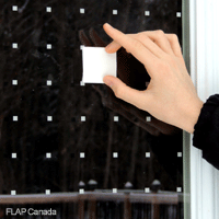
Image source: FLAP Canada

Bird friendly art at the CIRS Building. Image source: Corim De Guzman
Illustrative map of Pacific Flyway.
Image source: Washington Department of Fish & Wildlife